Shipwreck Tester
  • Shipwreck Viewer
  • News & Events
  • Gallery
  • Contact
  • Click to open the search input field Click to open the search input field Search
  • Menu Menu
  • Unlocking the Secrets of the Seabed

  • Finding Our Sunken Treasures
  • Advanced Seabed Mapping
  • Dynamic Seabed Viewer

About Us

Thanks to advanced sonar technology, the waters surrounding the islands reveal a remarkable underwater landscape—home to historic shipwrecks, dramatic submarine cliffs, sweeping sandbanks, and diverse marine habitats. These environments, largely unexplored, offer valuable opportunities for oceanographers, marine scientists, and adventurous divers alike. Many of these sites are potential candidates for protection, and the data we gather will be essential to deepening our understanding of this hidden world.

Channel Islands Hydrographic Survey was established in 2025 to survey and chart shipwrecks and seabed features around the Channel Islands. Our volunteer team includes researchers, maritime archaeologists, marine scientists, and divers from across the islands.

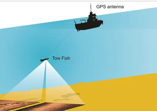
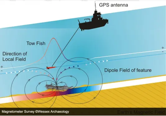
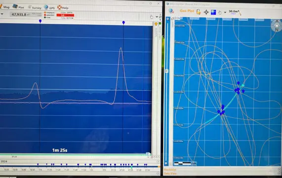
Using high-resolution multibeam sonar, side-scan sonar, and underwater magnetometers, we will locate, survey, and generate detailed 3D images of the seabed, shipwrecks, and other underwater features we discover.  Our aim is to collect high quality subsea data that can benefit the general public, marine scientists, conservationists, and other stakeholders interested in our maritime environment.

  • Finding Our Sunken Treasure

Exploring for Shipwrecks

Shipwrecks are an integral part of our submarine landscape and maritime heritage. The waters of the Channel Islands contain hundreds of known and as yet undiscovered shipwrecks from all ages.

Our aim is to find and survey as many of these wrecks as possible using ultra high resolution multibeam and side scan sonar equipment, at an adequate special resolution to establish a comprehensive database for future monitoring initiatives. Other techniques will be used as progress is made and the database is expanded.

With the help of local fishermen, divers and marine archaeologists, we hope to locate and survey as many of the known shipwrecks as possible in order to provide a high-quality database. The project will commence within the territorial waters of the island of Jersey but will also include specific sites within the waters of the Bailiwick of Guernsey.

  • Advanced Seabed Mapping

A Seabed Mapping Initiative for the Channel Islands

Primary marine bathymetry datasets derived from full coverage high resolution multibeam sonar surveying, is critical for the development of marine knowledge, economy, and policy, as well as the protection of the marine environment of the Channel Islands.

Exposed to view of our advanced sonar technology, the Island’s waters reveal a fantastic array of submarine cliffs, sweeping sand dunes as well as a multitude of diverse marine habitats just waiting to be explored by oceanographers, marine scientists and intrepid divers. Many of these unexplored habitats will be candidate for protection and the data we collect will be a crucial starting point for this work.

Almost all activities in the ocean are underpinned by marine geospatial data. Our aim is to collect high-quality bathymetric data to UKHO standard S-102 for submission and validation by the Admiralty to support safety of navigation, environmental and scientific study.

Science, Collaboration and Education

The survey data will provide an important resource for informing multiple disciplines and become accessible to the broader scientific community, supporting research, maritime archaeology and public engagement. Through collaboration with UK universities we hope to explore and map areas of special scientific interest in Channel Island Waters and make the data available for future research.

  • Dynamic Seabed Mapping

Discover Our Maritime History and Our Amazing Seabed

Launch Date: August 2025

PHASE 1: Summer 2025

10 shipwrecks, 10 Seabed features of special Interest and 5 Sites of Special Scientific Interest to be mapped.

The bathymetric datasets will be uploaded and displayed on the Seabed Viewer.

Details of each shipwreck will be published, and links provided to other databases when available.

Datasets will be regularly uploaded to the Seabed Viewer. This will be patchy at first but will develop over time.

Boats and Equipment

See what we use to find stuff

  • Survey Boat
  • Side Scan Sonar
  • Marine Magnetometry
  • Multibeam Sonar

Operational Updates

Find out what we’re up to

  • News & Events

Multibeam Sonar

Multibeam sonar is a technique used to map the seafloor and create detailed 3D bathymetric maps: The sonar sends out multiple sound waves in a fan-shaped pattern, simultaneously, from a transducer array mounted on the ship’s hull. The time it takes for the sound to return to the array after hitting the seafloor is measured to calculate the seafloor depth, or bathymetry.

This technology is widely used in a variety of applications, including underwater geological mapping, shipwreck search and research, and marine environmental monitoring. The hull-mounted sonar transducer/receiver can be operated at speeds of up to 11 knots, enabling rapid coverage of large areas of the seabed. Marathon is equiped with a Norbit WBMS Tx Wide Band Multibeam Sonar, 460 to 700 kHz for ultra-high-resolution images.

Side Scan Sonar

Side Scan Sonar is a sonar technology that plays an integral role in seafloor mapping and subsurface observation. Using the principle of sound reflection, slide scan sonar is able to produce detailed images of the seafloor and objects on the seafloor with a high level of resolution.

Marathon is equipped with a C-Max CM2 EDF sonar with a deck winch and 200m cable.

The main advantage of slide scan sonar lies in its ability to provide a full visualization of the scanned area, allowing researchers, oceanographers and other interested parties to better understand the characteristics of the seafloor and other underwater phenomena. The towfish is usually towed behind the surface vessel at speeds of between 2 and 5 knots.

Marine Magnetometry

Marine Magnetometry Local variations in the Earth’s magnetic field are most often caused by ferromagnetic objects or other magnetic objects located on nor under the sea floor. Through measuring and recording of this variation, it is possible to detect objects submerged beneath the water (and sediments).

An accurate map of the object’s position can be created by recording the sensor’s position along with the magnetic variation. The magnetometer is installed in a water-tight tow fish, which is towed behind the vessel using a tow cable. Marathon is equipped with a Marine Magnetics SeaSpy Explorer magnetometer with an Overhauser sensor.

Further Links

Charitable Purpose

Partners:

Footer Content

Address, or contasct details or whatever

Pages

  • Advanced Seabed Mapping
  • Boats and Equipment
  • Channel Islands Hydrographic Survey
  • Channel Islands Hydrographic Survey v2
  • Charitable Purpose
  • Dummy Welcome
  • Dynamic Seabed Viewer
  • Finding Our Sunken Treasures
  • Footer
  • Gallery
  • News & Events
  • Sample Page
  • Shipwreck Viewer
  • Shipwreck Viewer Full
  • Surveys
  • WorkingCopy

Categories

  • 3D Views
  • News

Archive

  • April 2026
  • April 2025

Archives

  • April 2026
  • April 2025

Categories

  • 3D Views
  • News

Pages

  • Advanced Seabed Mapping
  • Boats and Equipment
  • Channel Islands Hydrographic Survey
  • Channel Islands Hydrographic Survey v2
  • Charitable Purpose
  • Dummy Welcome
  • Dynamic Seabed Viewer
  • Finding Our Sunken Treasures
  • Footer
  • Gallery
  • News & Events
  • Sample Page
  • Shipwreck Viewer
  • Shipwreck Viewer Full
  • Surveys
  • WorkingCopy

Categories

  • 3D Views
  • News

Archive

  • April 2026
  • April 2025
© Copyright - Shipwreck Tester - powered by Enfold WordPress Theme
Scroll to top Scroll to top Scroll to top